East Fork near the Shut-Ins
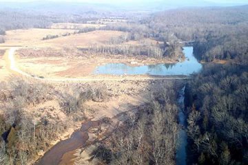 I've been searching for an aeriel photo of the Shut-Ins area and finally found one. To orient those of you that have been to the park, we are looking north. Highway N runs across the photo and there is a temporary road coming off N and leading to the east side of the river. What looks like a pond is the scour hole that was formed by the force of the water coming down the mountain. What is important to me in this photo is the new river bed heading to the lower left that goes through one of the campground areas. You can see the original river bed along the right side of the photo. I hope that we can learn from DNR tomorrow night what the plans are to put the river back on its original course. Additional aeriel photos are posted on the Johnson's Shut-Ins site.
posted by staff @ 6:38 PM
0 comments
![]()

0 Comments:
Post a Comment
<< Home